
Thunderstorms fire up and heavy rain streams across southeast Australia
A dynamic weather pattern is bringing about areas of scattered thunderstorms and moderate to heavy rainfall across parts of NSW and Victoria on Saturday. This is due to a low situated over southeast Australia that we touched on yesterday.
Severe thunderstorms across NSW, expected to impact Sydney and surrounds
Thunderstorms are currently stretching along a line from the NSW south coast through the Central Tablelands, with scattered storms also popping up across the state’s Riverina district and northern and eastern Vic. Some of these thunderstorms have prompted a severe thunderstorm warning from the Bureau of Meteorology, with damaging winds, large hail and heavy rainfall.
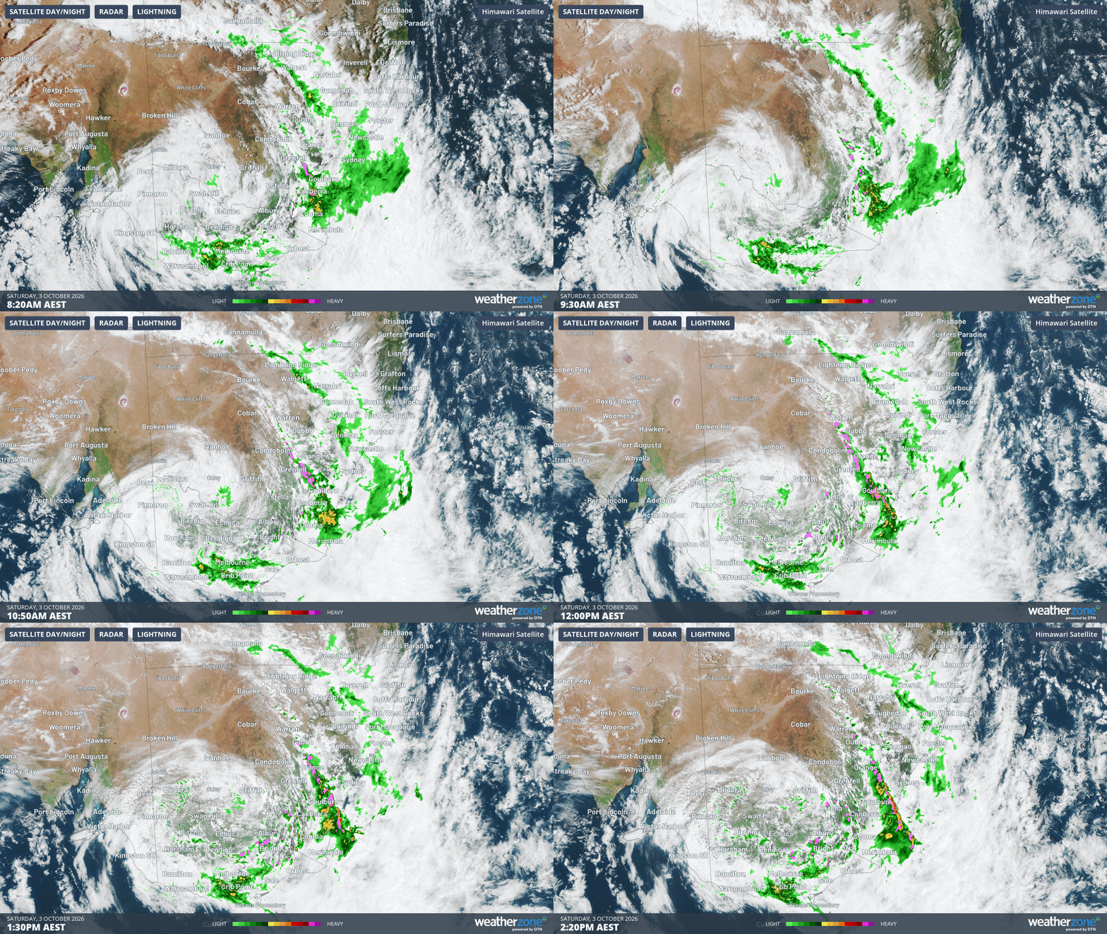
Gif: Satellite image with radar and lightning pulses over southeast Australia this morning and early afternoon. Source: Weatherzone
Some rainfall totals between 9am and 2:30pm AEST associated with these storms include 52.0mm at Morton, 41.0mm at Bawley Point Road, 34.6mm at Goulburn, 26.0mm at Ulladulla and 24.4mm at Orange. Ulladulla also recorded a wind gust of 98km/h around 1pm as the storms passed.
The aforementioned line of thunderstorms is expected to reach eastern NSW later through Saturday afternoon, likely to impact parts of Sydney, Central Coast and the Illawarra with localised heavy rain, damaging winds and large hail.
Heavy rain overnight for Victoria, continuing through Saturday and Sunday
On the other side of the low, heavy rain has continued over southern and western Victoria overnight Friday and into Saturday morning. The highest rainfall total in the 24 hours to 9am EST was at Mt Cowley (103.4mm) on the Otway ranges southwest of Melbourne, closely followed by Mt Sabine just to the southwest (91.2mm). Further inland, the town of Warracknabeal in the Wimmera district picked up 48.2mm, its highest 24 hour total since January 2022.
Heavy rainfall has continued in a moisture laden airstream across parts of elevated and coastal southern Victoria through the morning and early afternoon. Between 9am and 2:30pm, heavy rain has been recorded at Mt Baw Baw (42.6mm), Geelong Racecourse (31.2mm) and Mt Useful (30.0mm).
The heavy rainfall across Victoria has also led to a flood watch being put into place across eastern and central Victoria, with a few flood warnings also current in the area.
Rainfall to clear through Sunday
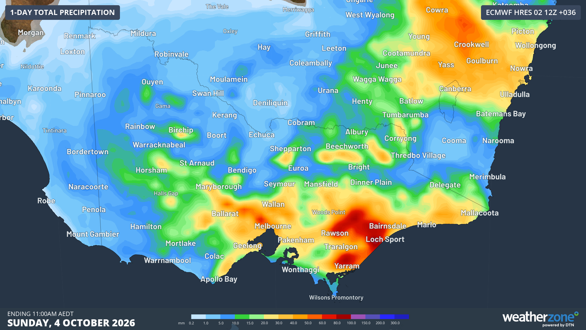
Image: Forecast rainfall in the 36 hours to Sunday 4th 11am AEDT for Victoria. Source: Weatherzone
The system is expected to bring localised totals of 100-150mm across the Otways as well as elevated and coastal parts of the Gippsland areas in addition to the rain that fell on Friday night. The low and trough will start to move off the east coast overnight on Saturday, taking most of the rainfall with it. By Sunday, heavy rain will be largely confined to the East Gippsland coast of Victoria and the far southern South Coast of NSW.
A high pressure ridge should move in on Monday, bringing a dry end to the long weekend for those in central and southern NSW, and a dry start to the working week for those in Victoria.
Until the system passes, you can keep up to date with weather warnings impacting you here: https://www.weatherzone.com/au/warnings