
Winter arrives early this year in SA
If you live in SA and are not a big fan of cold, enjoy the early-autumn like temperatures on Sunday and Monday before a burst of wintry weather hits the state.
Well above average temperatures are set to continue in SA over the next couple of days thanks to northerly winds. Adelaide saw top temperatures of 25°C and 24°C on Friday and Saturday, respectively, which represent around 5-6 degrees warmer than climatology in May. Maxima should continue in the mid 20s on Sunday and Monday.
Dry winds will start to strengthen during Monday as a front and low pressure trough approaches from the west late in the day. Consequently, areas of raised dust are possible over western and central parts of the state, including Eyre and Yorke Peninsulas.
Showers will develop from Monday afternoon in the far west of the state and extend gradually to the east overnight and during Tuesday. Rain should reach Adelaide in the early hours of Tuesday and persist much of the day. Thunderstorms may also affect the southeast of SA in the afternoon and evening.
Many places across central and southern districts could pick up 10-20mm of rain, with the heaviest falls expected over Lower Eyre Peninsula, Kangaroo Island, and Mount Lofty Ranges. Rain should be insignificant for northern parts of the state.
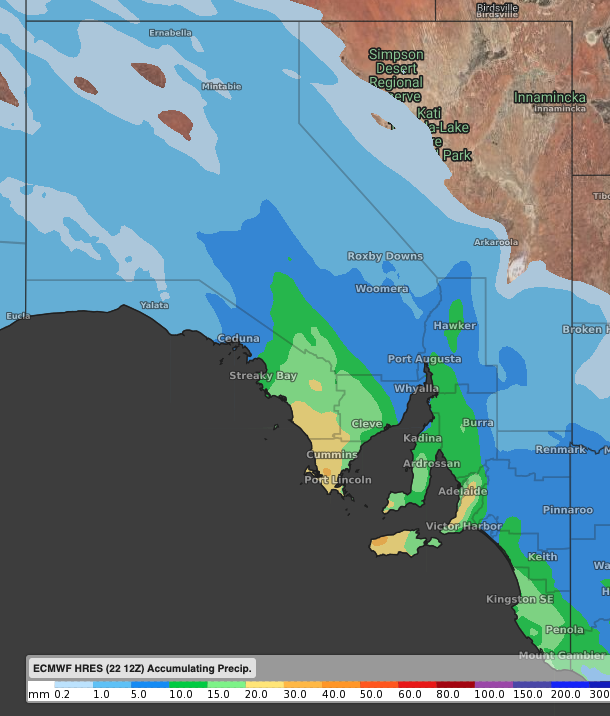 Image: Forecast accumulated rain until Tuesday night according to the ECMWF-HRES model.
But if you think that having an umbrella handy should make things easier, do not be surprised if you are unable to open it up or if it blows away. The system will bring also generate strong gusty winds, around 60-75km/h in Adelaide. Furthermore, localised damaging winds associated with heavy showers cannot be ruled out.
A cold airmass behind the front will also result in a significant drop in temperatures, around 6-8 degrees compared to Monday, with the mercury staying below the mid-teens across much of the state. On top of that, wind chill should take 4-5 degrees off.