
Three hurricanes could affect U.S. weather through next week
Three hurricanes from the Pacific to the Gulf are going to have an outsized influence on the U.S. weather forecast over the next 7–10 days. However, there is a high degree of forecast uncertainty surrounding this dynamic weather pattern.
Hurricane Isaias to develop in the Gulf
Tropical Storm Isaias was located in the southern Gulf as of 7 pm CDT on Wednesday, October 7, with maximum sustained winds of around 55 kts. The incredibly warm waters of the Gulf are expected to aid in rapid strengthening of the storm into a hurricane by Thursday morning, October 8.
Once formed, the hurricane is expected to move northward through the Gulf on Thursday and Friday, October 8–9, likely making landfall somewhere along the northern Gulf Coast Friday night or early Saturday morning. The official forecast from the National Hurricane Center has Isaias reaching Category 1 or 2 strength before landfall.
At landfall, Isaias is expected to bring damaging winds to parts of the coast, with potential for widespread damage. The rapid intensification of the hurricane is likely to bring a large storm surge, especially east of the storm track.
Heavy rain will hit the coast with current projections somewhere in the 5- to 10-inch range. Embedded tornadoes will also be possible, with the tornado threat to extend inland on the eastern side of the storm track after landfall.
From there, Isaias will move northward through the southeastern quadrant of the U.S., with its remnant low-pressure center expected to move north of the Ohio River on Sunday, October 11, before shifting into the Northeast on Monday, October 12.
Rain associated with Isaias will overspread much of the country east of the Mississippi River between Saturday and Monday, October 10–12, which could cause some areas of flooding, especially where heavy rain occurs in areas that have seen a lot of rain recently in the Midwest, Mid-Atlantic, and Northeast.
It should be noted that there remains some uncertainty in the exact track, intensity, and timing of this hurricane as it moves through the Gulf over the next two days. Those in the ‘cone of uncertainty’ – the area designated by the NHC as the most probable track of the hurricane’s center – should pay special attention to the forecast. You can keep aware of the latest from the National Hurricane Center here: https://www.nhc.noaa.gov/.
Hurricane Rachel moving over Eastern Pacific
Hurricane Rachel has been moving through the Eastern Pacific Ocean for the last 12 days. After briefly reaching category 3 strength as it moved west from the Mexican coast on October 2, the system is forecast to weaken into a tropical storm as it moves over cooler waters on Wednesday and Thursday, October 7–8.
Rachel is forecast to turn towards the northeast on Thursday, October 8 and track toward the northern Baja California Peninsula, where it may make landfall on Saturday night into Sunday, October 10–11 as a tropical storm.
After making landfall, Rachel’s remnant low-pressure center is forecast to interact with an upper-level trough to bring widespread tropical moisture into the Desert Southwest and Great Basin for Sunday and Monday, October 11–12. Areas of heavy rain are likely to overspread southern California, Arizona, Nevada, and Utah. Rainfall amounts are currently being forecast in the 1- to 3-inch range and will be enhanced in areas with mountains. While much of this region is in drought and will happily accept the rain, some areas are likely to experience flooding.
Interaction with this trough and where it may go from there are some of the uncertainties affecting the forecast for next week. Precipitation amounts not only across the Western U.S., which will see the primary impacts, but also across the northern tier of the U.S. are also uncertain.
Some forecasts have the remnant low being absorbed in the western trough. However, others push the remnant low-pressure center into the Northern Plains early next week, north of a cold front that will be well to the south. With some colder air in place behind the front, there is a risk that whatever remains of the remnant low could produce accumulating snowfall somewhere in the region Sunday and Monday.
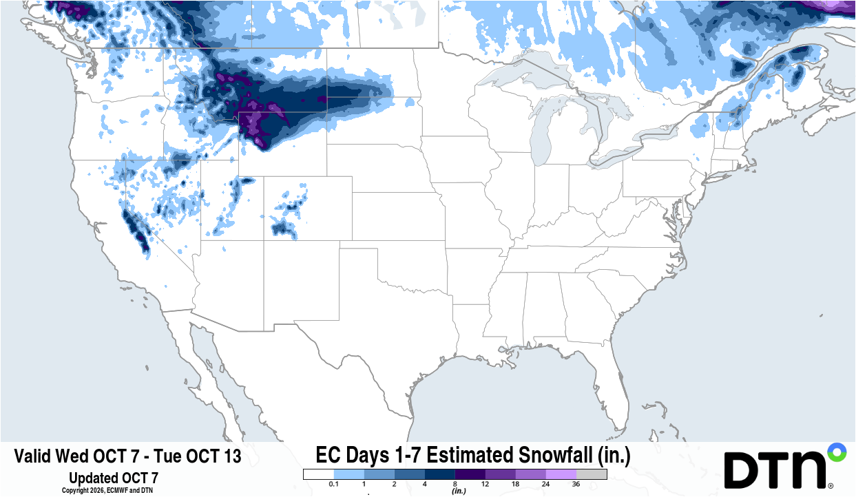
Image: Forecast accumulated snow between Wednesday, October 7 and Tuesday, October 13. Source: DTN.
Soon-to-be Hurricane Simon to approach Mexico, southwestern U.S.
A third tropical system is in the early stages of development off the southern coast of Mexico. The official NHC forecast has this system becoming a hurricane on Thursday night before approaching the west-central coast of Mexico as a major hurricane on Sunday.
Like Rachel, Simon’s remnants could move northward into the U.S., interacting with the western trough early-to-mid next week.
Since this hurricane has yet to form and is almost a week away from moving into the U.S., the impacts from this system are highly uncertain. However, much like Hurricane Polo last week, Simon will have the potential for spreading heavy rain into the Four Corners area and Southern Plains as the western trough makes a move eastward next week.
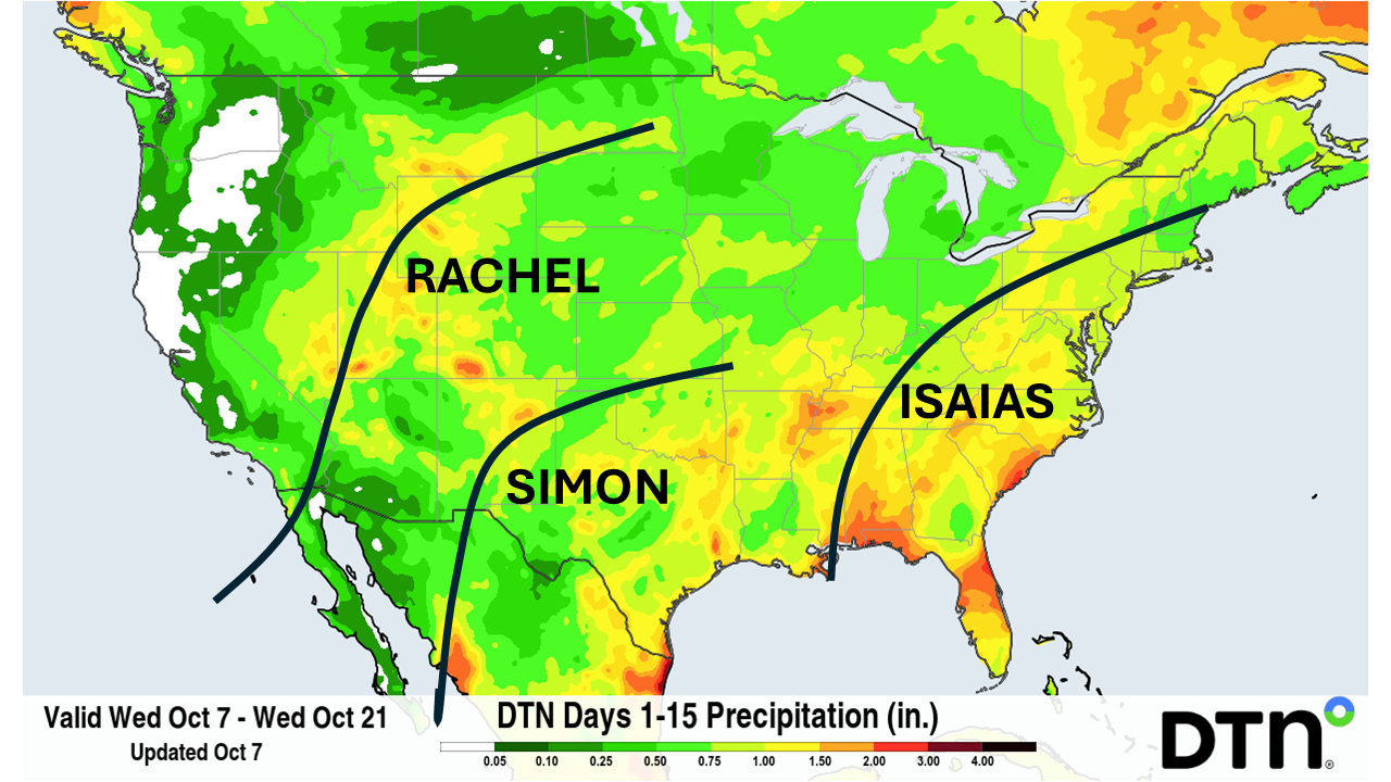
Image: Approximate future tracks of current and forecast hurricanes, combined with predicted accumulated rain between Wednesday, October 7 and Wednesday, October 21. Source: DTN.
Hurricane season being influenced by El Niño
The Pacific hurricane season has been extraordinarily busy in recent months under the influence of a strengthening El Niño. Simon will be the 21st named system and 11th hurricane for the 2026 hurricane season, which includes three rare storms that formed in the Central Pacific. Eight of these have become major hurricanes, making it to at least Category 3 strength. Simon will have some potential to become the ninth as waters off the coast of Mexico are extremely warm for this time of year to allow for rapid intensification.
By contrast, the Atlantic hurricane season has been exceptionally quiet until now. Isaias will be the first hurricane of the 2026 hurricane season in the Atlantic, which will be the latest that the first hurricane of the season has formed in the Atlantic during the satellite era.
Including records prior to the satellite era, which contain some observation limitations and are less reliable, Isaias will become the latest first hurricane of the season going back to 1905. In that year, the season’s first Atlantic hurricane formed on October 8.
This year’s contrast between an active Pacific season and quiet start to the Atlantic season showcases the incredible effects that El Niño can have on hurricane development across North America.