
Rain and thunderstorms to spread over eastern Australia this weekend
Rain and storms will affect broad areas of Queensland, NSW, the ACT, Victoria and Tasmania this weekend, with severe thunderstorms possible in several states.
What will cause this weekend’s stormy weather?
A low pressure trough and cold front will trigger widespread showers and thunderstorms across Australia’s eastern and southeastern states this weekend. This wet and stormy weather will be fuelled by abundant tropical moisture and enhanced by copious atmospheric instability.
Friday provided a preview of the systems that will drive this weekend’s storms, with the trough already producing thunderstorms over inland Qld and the developing front generating rain and storms over parts of SA.
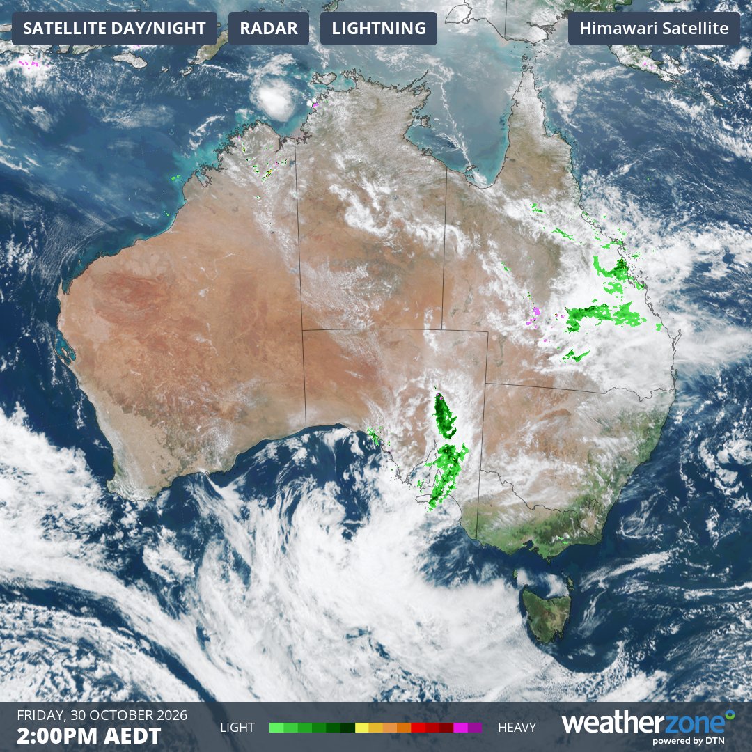
Image: Composite satellite, radar and lightning observations at 2pm AEDT on Friday, October 30, 2026, showing rain and thunderstorms over Queensland and SA. Source: Weatherzone.
Southeastern Australia: Storms and damaging winds on Saturday
The front and an associated low pressure system will move across southeastern Australia on Saturday, causing rain, thunderstorms and blustery winds to spread over parts of Victoria, Tasmania, NSW, the ACT and the southeast of SA.
Saturday’s storms will be fast-moving as they sweep across southeastern Australia. This will reduce the likelihood of heavy rainfall but increases the risk of damaging wind gusts. The Bureau of Meteorology may issue severe thunderstorm warnings as storms develop on Saturday.
Melbourne and Canberra both have a chance of thunderstorms on Saturday. Melbourne’s highest chance will be in the late morning and early afternoon, while Canberra’s storm risk increases in the afternoon and early evening.
In addition to the rain and storms, a burst of powerful northwesterly winds will also develop ahead of the approaching front on Saturday. These winds could reach damaging strength in parts of northeast Victoria and southern NSW, most likely about higher parts of the ranges.
Sunday is expected to feature more settled weather across southeastern Australia in the wake of the front.
Eastern Australia: Storms spreading east and north during the weekend
Queensland and NSW could both see severe storms this weekend.
On Saturday, the focus of rain and thunderstorms will most likely stretch across an inland corridor from central NSW up to southern Queensland, along a low pressure trough. There will be plenty of instability and moisture to support storms in these areas, so severe thunderstorms producing damaging winds, large hail and heavy rain are possible.
Saturday’s stormy weather may also extend up to parts of northern Queensland and across to eastern NSW. The Sydney region has a chance of storms in the afternoon and evening.
On Sunday, rain and thunderstorms should spread further north and east across northeast NSW and southeast Queensland. This could be another day of severe thunderstorms in these areas. Brisbane may see storms on Sunday afternoon or early evening as convective activity ramps up across southeast Queensland.
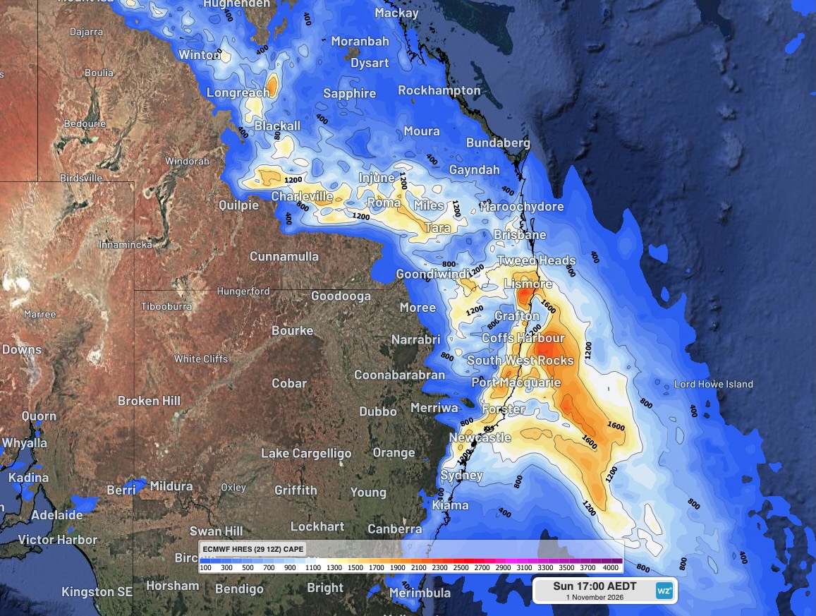
Image: Convective available potential energy (CAPE) over eastern Australia at 5 pm AEDT on Sunday, November 1, 2026. CAPE is a measure of atmospheric instability. As a general rule, the higher the CAPE the more energy available for thunderstorm development, should storms begin to form. Source: Weatherzone.
How to stay ahead of this weekend’s potentially severe weather
Forecasts are a good way to see what types of weather may be coming up for your location. However, once rain and thunderstorms start to develop, observational tools like satellite and radar images and lightning strike observations become more useful.
Severe weather and severe thunderstorm warnings issued by the Bureau of Meteorology will also contain the most up-to-date information on heavy rainfall, damaging winds and severe thunderstorms. These warnings are available from the Bureau’s website and also on the Weatherzone website and app.
For emergency help in severe weather, including flooding and thunderstorms, ring the SES on 132 500. In life-threatening emergencies, call 000 (triple zero) immediately.