
Prolonged period of warmth for several southeastern capitals
A surge of warmth is coming to at least three capital cities in southeastern Australia (and nearby regions). Unusually for this time of year, the spell of warm, stable weather is set to last for around a week.
During spring, we often hear about the so-called spring temperature "see-saw", when maximums can fluctuate quite dramatically from one day to the next across southern Australia. For example:
- Just this week, Sydney went from a high of 34.8°C on Monday to a maximum below 20°C on Tuesday, and a top of just 16.9°C on Thursday as cool air lingered.
- Hobart topped out at just 12.8°C this Tuesday but its forecast high is already 23°C this Friday.
But for the next week, three capital cities in particular – Melbourne, Adelaide and Hobart – will be consistently warm without a significant break in the prevailing weather conditions.
The week ahead for Melbourne, Adelaide and Hobart
After an expected peak of 23°C this Friday, Melbourne is forecast to reach highs of 25°C, 25°C, 27°C, 28°C, 26°C and 29°C up until next Thursday, with nothing more than a very light shower in the forecast on one or two of those days.
Adelaide should reach 26°C this Friday, after which it can expect highs around 27°C, 29°C, 30°C, 25°C, 25°C and 30°C between Saturday and next Thursday.
After this Friday's high around 23°C, Hobart locals can look forward to a rare run of six October days in at least the mid-twenties, with maximums around 24°C, 25°C, 27°C, 27°C, 24°C and 28°C.
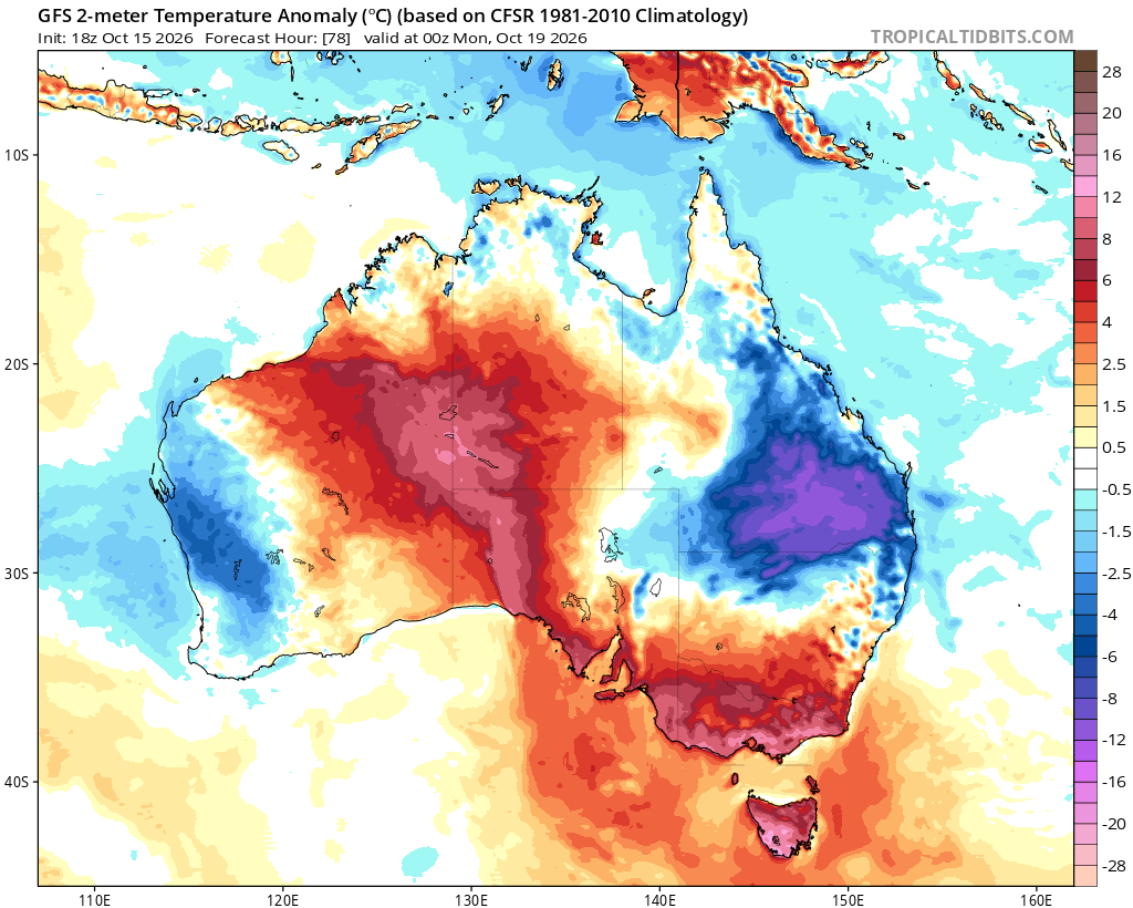
Image: Temperature anomalies across Australia predicted for the morning of Monday, October 19, 2026, showing how Tasmania, Victoria and parts of SA near Adelaide will be warmer than usual, while the east coast from Sydney to Brisbane and further north will be significantly cooler. Source: Tropical Tidbits.
As for the other southeastern capitals, Canberra will be a little cooler than the three cities just mentioned for the first few days of the coming 7-day period, hence it doesn't really qualify for the "prolonged period of warmth" mentioned at the top of this story.
Sydney will also be cooler than Adelaide, Melbourne and Hobart most days due to the influence of cool southeasterlies from the Tasman Sea which will push showers onshore from time to time.
Brisbane is also facing a cool spell. Maximums will be at least a couple of degrees below the October average of 27.2°C for the next week, again due to persistent coolish southeasterlies.
Why such a consistent weather pattern in the week ahead?
"The stagnant weather pattern across southeastern Australia will be caused by a high pressure system lingering between now and next Thursday or Friday," Weatherzone meteorologist Felix Levesque explains.
"The high will drive warm northerly winds towards Adelaide, Melbourne and Hobart, while Sydney and Brisbane get an onshore flow with cloud, showers and milder temperatures.
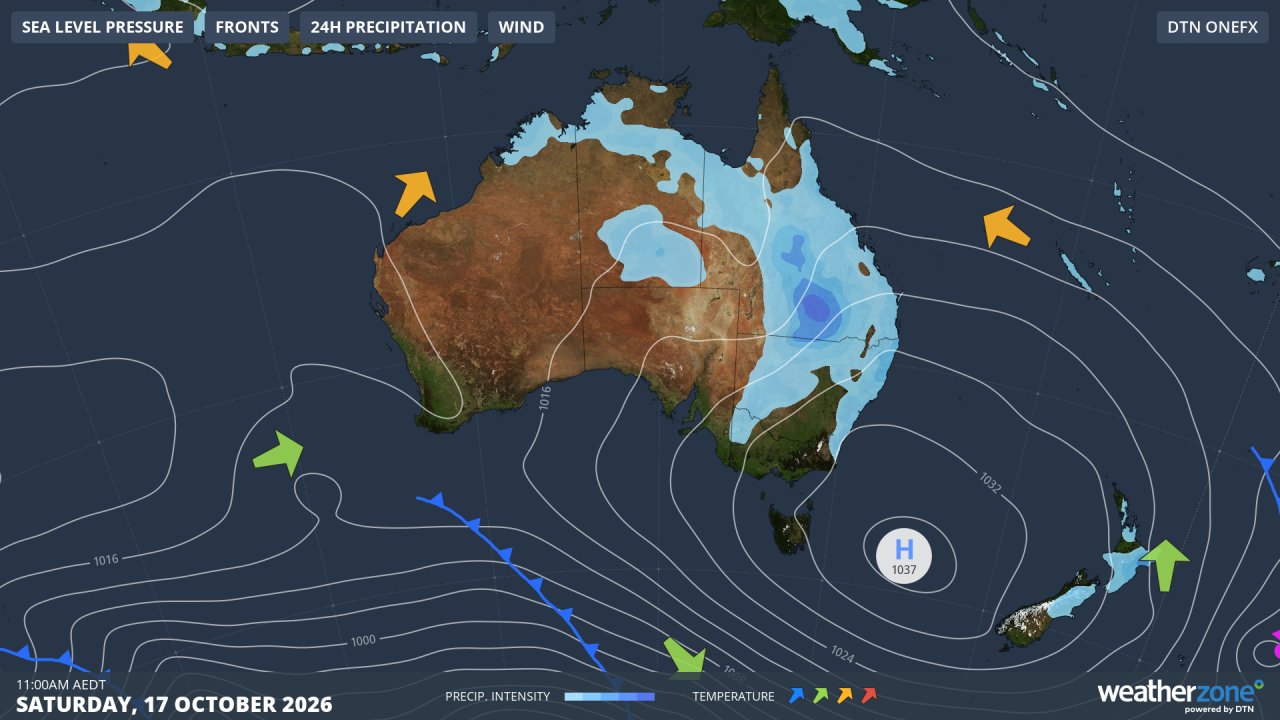
Image: Synoptic chart for Saturday, October 17, 2026, showing air circulating anti-clockwise around the high, pushing moisture onshore and dragging warm air from the interior of the mainland towards Adelaide, Melbourne and Hobart. Source: Weatherzone.
If you compare this coming Saturday's and nest Tuesday's synoptic charts (above and below), you can see how there is very little change in the weather pattern, as the centre of the high drifts very slowly over the waters of the Tasman Sea towards New Zealand.
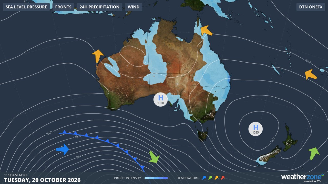
Image: Synoptic chart for Tuesday, October 20, 2026, illustrating how the position of the high will change only very slightly over three days. Source: Weatherzone.
The high is preventing the classic spring temperature see-saw by steering any cold fronts well south of Australia, such as the one we saw earlier this week that brought snow to Tasmania.