
Perth facing sixth consecutive month of below-average rain
Perth is facing the strong likelihood of enduring six-straight months of below-average rainfall in what historically are its six wettest months of the year.
While there are still a few days left in October, it's looking extremely likely that Perth's 2026 October rainfall will fall just short of the historical average.
It's also virtually certain that this will be Perth's driest May-to-October period in 20 years.
How much rain did Perth receive from May to October in 2026?
This year, Perth's running six-monthly rainfall total from May to October stands at 399.8 mm. That's just two-thirds of the long-term average.
Overall, Perth receives 600.1 mm on average across its six wettest months. That's 83% of its annual average of 721mm, which underlines the importance of cool-season rain.
Here's a month-by-month breakdown of Perth's rainfall totals from May to October 2026:
- May average: 84.5 mm. May 2026 total: 53.2 mm
- June average: 127.0 mm. June 2026 total 121.6 mm
- July average: 145.2 mm. July 2026 total 56.8 mm
- August average: 124.3 mm. August 2026 total 97.0 mm.
- September average 79.7 mm. September 2026 total 38.6 mm
- October average 39.4 mm. October 2026 running total 32.4 mm (with further significant rain unlikely)
Dry Perth winter, wet in some parts of South West Land Division
In years when Perth and the far southwest of WA have had a relatively dry winter, it's usually safe to assume that it was even drier as you headed north or east into the Wheat Belt, the Goldfields or other inland areas.
That's because the heaviest winter rainfall tends to arrive from the southwest via cold fronts. But that wasn't always the case this year.
At times during the 2026 winter, northwest cloudbands transported Indian Ocean moisture diagonally across the country in a generally southeasterly direction.
Perth and the far southwest tip of WA missed that rainfall, but some inland parts of southern WA (including large towns like Esperance and Kalgoorlie) had their seasonal totals hugely boosted by one or two very damp weather events.
Meanwhile, cold fronts were less frequent in the southwest than in a typical winter.
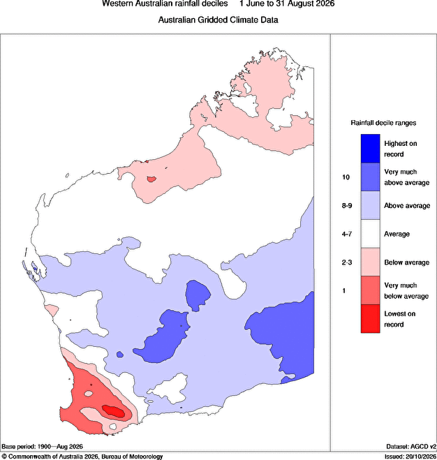
Image: WA rainfall deciles for winter 2026, showing how winter 2026 saw above average rainfall in some parts of the South West Land Division. Source: BoM.

Perth falls short of October rainfall average despite handy overnight rain
Perth received 7.2m of rainfall in the 24 hours to 9 am this Monday, but despite the steady showers across the city (and other parts of the southwest), the WA capital looks likely to fall slightly short of its October rainfall average in 2026.
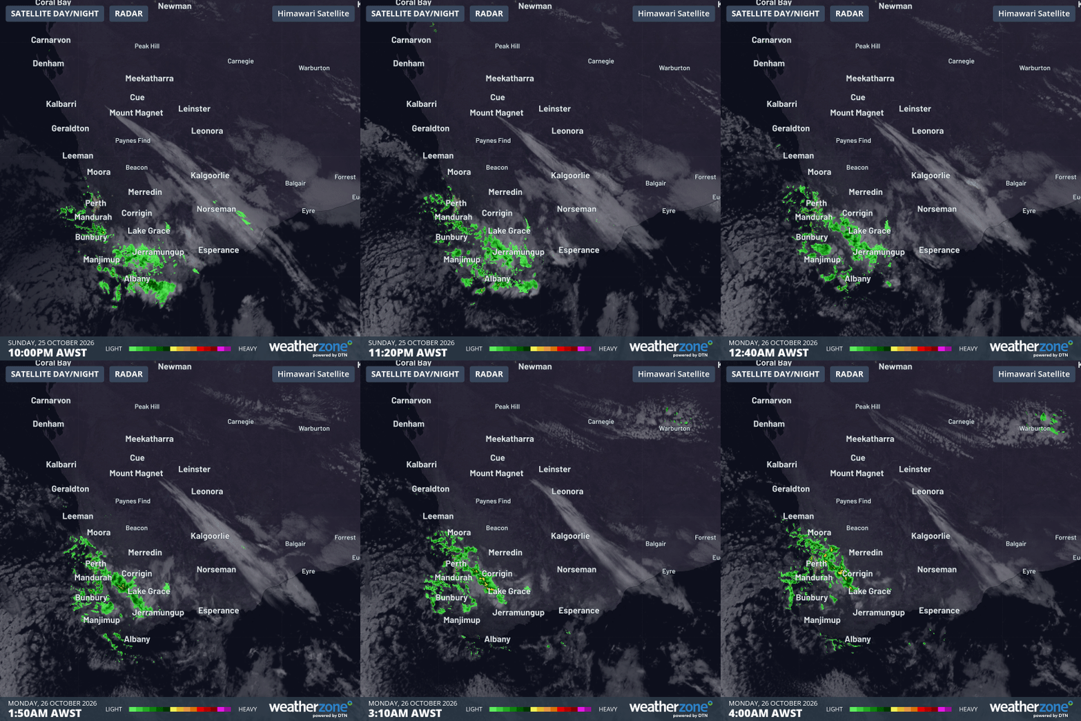
Image: Six-hour radar and satellite loop to 4 am (AWST) on Monday, October 26, 2026. Source: Weatherzone.
With the early morning showers having pushed north of the city, Perth is now expecting sunny weather for several days.
While this Friday, October 30, could see a shower, persistent showers more likely to occur on Saturday, October 31.
Since any rain that falls after 9 am on the last day of any month is counted in the 24-hour meteorological day ending at 9 am on the first day of the new month, Saturday's rain will be counted as November rain.
That's a slightly technical point, but the bottom line is that this morning's rain was almost certainly Perth's last chance to beat its monthly average in October 2026. Unfortunately, the totals from this event weren't quite high enough.
Strong climate signal evident in long-term southwest WA rainfall decline
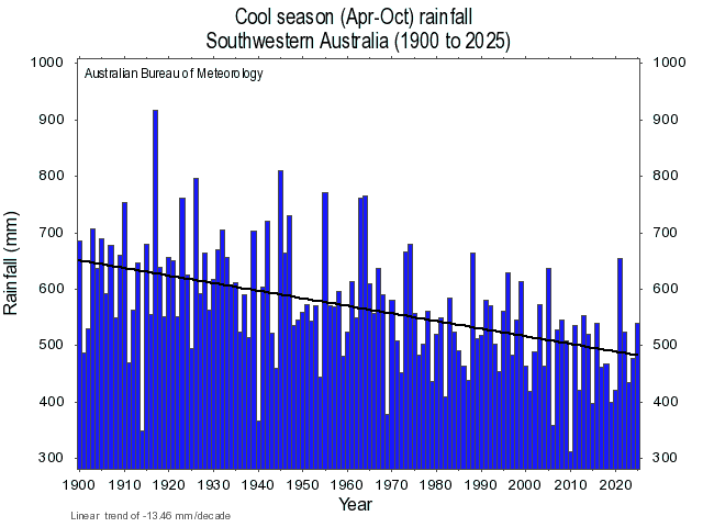
Image: April to October rainfall in southwestern Australia from 1900 to 2025, showing a steep decline over time. Source: BoM.
Rainfall has been steadily declining in the southwest of Western Australia, in one of the clearest signals of the influence of the warming climate anywhere in Australia.
In 2019, the BoM published a fact sheet on weather in the Perth region that included the following points about the area's weather in the previous 30 years:
- Annual rainfall had decreased by 9%.
- Dry years (in terms of rainfall compared to the long-term average) occurred far more often than wet years.
- Rainfall had decreased in the autumn and winter months.
- There were more hot days.
- The number of winter frosts at Mundaring in the Perth Hills had increased. (While this fact appears to contradict the warming trend, it is a reflection of declining rainfall which has enabled more clear nights conducive to cold mornings and frost).
According to the BoM, the shift towards drier conditions in the southwest (and also to an extent in the southeast) in the cooler months is due to "a combination of natural variability on decadal timescales and changes in large‑scale circulation caused by increased anthropogenic greenhouse gas emissions."