
Month's rain in two hours as storms light up northern NSW, southern Qld
An outbreak of thunderstorms has produced heavy localised rainfall across a large swathe of northern New South Wales and southern Queensland on Wednesday afternoon, with storm activity continuing into the evening.
A severe thunderstorm warning for damaging winds, large hailstones and heavy rainfall for parts of the Central Highlands and Coalfields, Central West, Maranoa and Warrego and Channel Country forecast districts was issued at 4:23 pm (AEST) on Wednesday.
While no equivalent warning was issued for New South Wales during the afternoon, northern parts of that state have also been lashed by widespread storms, some of them delivering heavy rainfall within a short period.
Bourke receives its monthly rainfall in just two hours
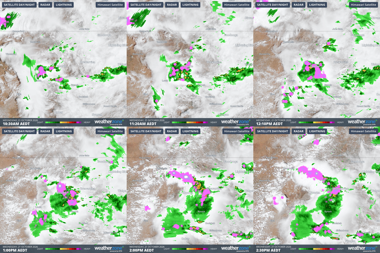
Image: Four-hour combined radar and satellite loop showing the storm around midday on Wednesday near Bourke, NSW. Source: Weatherzone.
Weatherzone meteorologist Ben Domensino wrote on Tuesday that some areas in Queensland and New South Wales were in line to receive more than one month’s rain in a matter of days.
Bourke in northwestern New South Wales achieved its monthly average in just two hours.
Bourke averages 26.1 mm of rainfall across the whole of October, but it received around 28 mm of rainfall between about 11:30 am and 1:30 pm (AEDT) as a large storm crossed the area (see loop above).
About five hours north of Bourke, the town of Charleville in western Queensland's Maranoa and Warrego forecast district received 16.2 mm in just half an hour in a different storm between 2:30 pm and 3 pm (AEST).
What is causing this stormy outbreak?
Two separate streams of moisture-laden air are colliding over eastern Australia.
The first source is coming from winds in the middle to upper levels of the atmosphere carrying moisture across Australia from the Indian Ocean.
In the lower atmosphere closer to the surface, winds are flowing towards Australia from the Coral and Tasman Seas, providing a secondary source of moisture above eastern Australia.
Stormy weather to persist for around a week
The stormy weather can be expected to continue for the best part of the next week, delivering much-needed rainfall to many locations.
For northern NSW and adjacent inland areas, and for southern and central parts of Queensland's coast and adjacent areas, this week should be by far the wettest spell since early autumn.
Virtually all of these areas had a very dry winter which was close to the driest on record (in some spots) followed by a relatively dry first half of spring.
Brisbane received just 22.4 mm of rainfall in the three months from July to September, but rain is on the forecast for each of the next seven days, with heavy falls possible some days and thunderstorms likely at times too.
Flood risk should be monitored
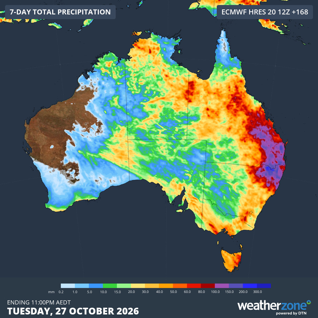
Image: Predicted rainfall totals across Australia up until Tuesday, October 27, 2026, showing how NE NSW and SE Qld are the areas forecast to see the heaviest totals. Source: Weatherzone.
With so much rain on the horizon, and with the likelihood of severe thunderstorms in some areas, the likelihood of both riverine flooding and flash-flooding will increase.
Please check the Weatherzone warnings page for the latest information.