
Little known El Niño measure hits record levels – here's why Australians should care
Sea surface temperatures in the far eastern tropical Pacific Ocean just reached their highest October values on record and have continued to warm to unprecedented levels in November. These record-breaking temperatures in a little-known corner of the Pacific highlight the extraordinary intensity of this El Niño event, which is expected to persist into 2027.
Most international weather forecasters typically refer to water temperatures in the Niño 3.4 region when monitoring El Niño. When this region – located in the central–eastern tropical Pacific Ocean – becomes sufficiently warmer than average for several consecutive months, it typically means that El Niño is underway.
However, another region of the tropical Pacific located much further east, near the coasts of Peru and Ecuador, has just warmed to record-breaking levels.
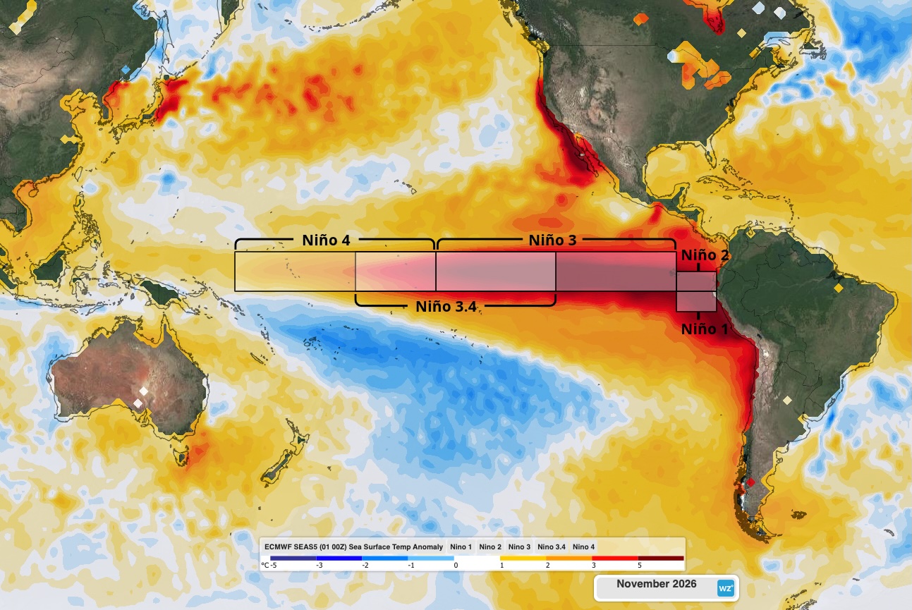
Image: Modelled sea surface temperature anomalies in the Pacific Ocean in November 2026, with the Niño regions highlighted. Source: Weatherzone.
Based on the relative Niño index – which compares how unusually hot or cold each Niño region is compared to the rest of the global tropics, to filter out the influence of long-term global warming – the far eastern tropical Pacific is currently running at record-breaking levels.
According to monthly averages from the Bureau of Meteorology, the relative Niño 1 index reached +4.11°C in October 2026. This was the highest monthly value in the Bureau’s records extending back to 1900, beating the old record of +3.83°C in December 1997. The relative Niño 2 index also reached +4.24°C last month, which was the second highest monthly value on record behind +4.27°C in December 1997.
The warm temperature anomalies in the far eastern tropical Pacific have continued to increase during the first half of November.
For the week ending on November 15, the relative Niño 2 index had risen to +6.34°C, while the relative Niño 1 index had climbed to +5.43°C. These are the highest weekly values of this year’s El Niño event for both regions.
What does this mean for our weather?
Water temperatures in the Niño 1 and Niño 2 regions don’t directly impact Australia. However, abnormally warm water in the far eastern tropical Pacific Ocean can be a sign that El Niño is continuing to strengthen across parts of the tropical Pacific.
Most computer models suggest that the current El Niño will continue to strengthen in the coming weeks, most likely peaking in November or December before weakening early next year. Due to its current strength, this El Niño event should persist through the Southern Hemisphere summer and last into autumn while weakening.
Abnormally warm water in the eastern Pacific can also have a big impact on weather patterns and marine life along the west coast of South America. When water temperatures are warmer than average in the Niño 1 and 2 regions, it can:
- Increase rainfall and flooding in coastal areas of Peru and Ecuador.
- Cause a higher chance of landslides along the typically dry slopes of the Andes Mountains.
- Bring higher temperatures and humidity along parts of the west coast of South America.
- Disrupt marine ecosystems, leading to losses of fish and other marine life.
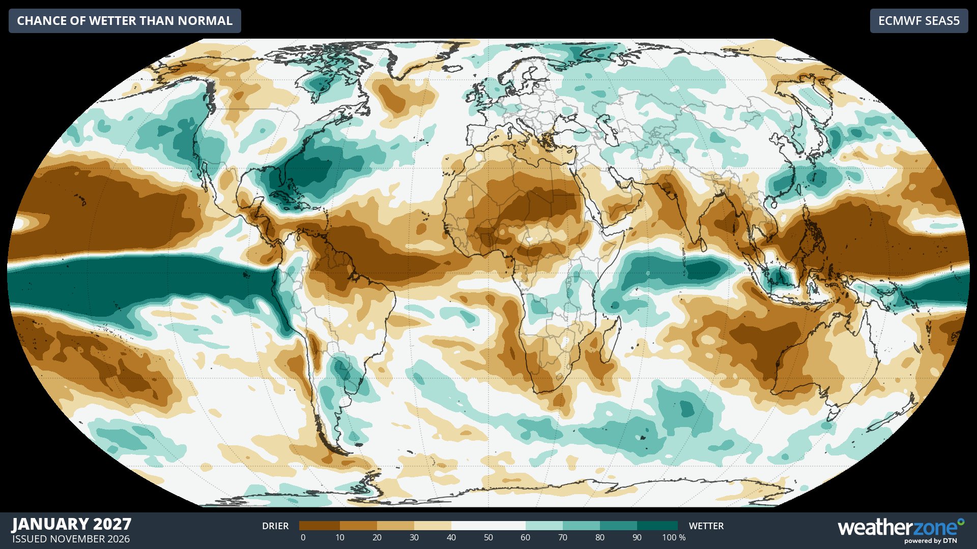
Image: Chance of exceeding average rainfall during January 2027, according to the ECMWF SEAS5 model. Source: Weatherzone.
Earlier this month, the Peruvian government declared a State of Emergency due to the dangers of intense rainfall associated with the current El Niño. Australia’s smart traveller website has the following update as of November 17, 2026:
“The Peruvian Government has warned that the El Niño climate pattern may increase the risk of natural disasters in parts of Peru and could disrupt infrastructure, transport services and public health systems.”
With El Niño likely to persist this summer, Australia has an increased likelihood of warmer-than-average temperatures during the season. Some areas of the country may also see unusually dry conditions in the coming months, however abnormally warm water in the Australian region may enhance evaporation and offset this dry signal for some areas. Check the latest seasonal forecasts for Australia to see how this ongoing El Niño is expected to impact the weather in the coming months.