
How the November 2026 Sudden Stratospheric Warming could affect US weather
A polar vortex disruption and sudden stratospheric warming (SSW) event occurred between November 11th and 13th; but will this have any impact on weather conditions across the US?
What is the polar vortex?
As days become shorter through the northern hemisphere’s fall and winter, the reduction of solar heating causes steady radiative cooling and creates a pool of very cold air high above the Arctic.
Because the air above the Arctic region cools more rapidly than the air at lower latitudes, it enhances the north-south temperature difference in the northern hemisphere.
This temperature gradient aids the development of strong circumpolar westerly winds in the stratosphere, which meteorologists typically measure at 60 degrees N latitude.
This is the polar vortex, and climatologically its strength peaks in midwinter before it weakens and eventually disappears in the spring. While it is strong, the polar vortex inhibits mixing of air between the polar stratosphere and the mid-latitudes.
Planetary waves and vortex disturbances
However, rarely does the polar vortex adhere to this simplified evolution. It often gets disturbed, displaced or split by strong atmospheric waves propagating northwards and upwards from the troposphere.
These planetary-scale waves, called Rossby waves, are generated or amplified by various means, such as mountain ranges, temperature contrasts between oceans and land masses.
When Rossby waves break in the stratosphere, they can cause a deceleration of the polar vortex’s circumpolar winds, or even a reversal. They can also allow stronger downwelling towards the pole with stratospheric temperatures rapidly rising – a process known as sudden stratospheric warming (SSW).
State of the polar vortex
An SSW event took place between November 11th and 13th, following a couple of attacks on the polar vortex by unusually strong Rossby waves in October and again in early November, which caused it to split and displace off the pole.
According to computer models, the polar vortex is already starting to recover and should attain at least average strength later in November and into December.
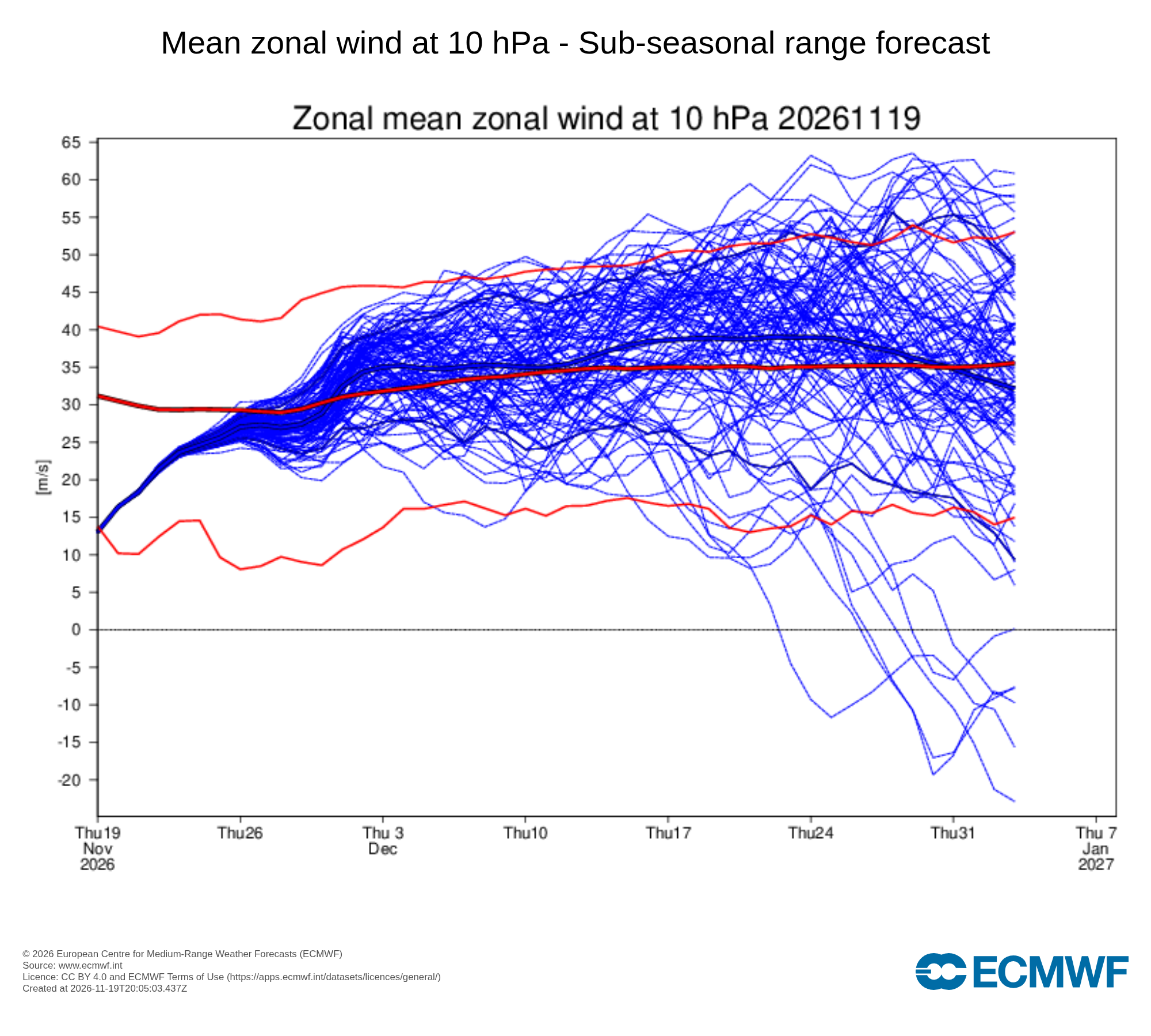
Image: Mean wind at the 10 hPa level at 60 degrees N latitude. The thin blue lines represent results from individual ensemble members from the ECMWF Sub-seasonal range model. The thick blue line shows the ensemble mean, or the average of all ensemble members. The thick red line is the climatological average. Below-average wind speeds are associated with a weakened polar vortex. Source: ECMWF.
However, despite the polar vortex recovering in the stratosphere, the effects of the SSW will slowly percolate downwards from the stratosphere and through the troposphere, potentially affecting circulations at the surface and redistributing or strengthening areas of high and low pressure in the coming weeks.
There is also potential for another SSW towards the end of this year, with a few ensemble members suggesting another possible weakening of the polar vortex again later in December, which is shown in the image above.
Historically early SSW and strong El Niño
The November 2026 event is unusual, and its impacts hard to assess, because it was much earlier than any previous SSW on record. Intense planetary-wave activity disrupted its formation process almost as soon as the vortex had started to become established.
It’s plausible that this may in part be connected to the unusually strong El Niño episode in the central and eastern Pacific. This might have increased the background susceptibility of the polar vortex to disruption; but although that can occur during El Niño, it is not a particularly characteristic signature.
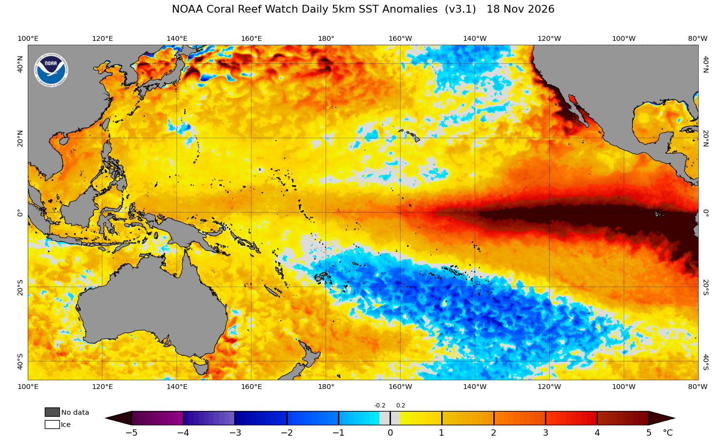
Image: Sea surface temperature anomalies in the tropical Pacific Ocean, showing a strong El Niño underway. Source: NOAA.
More typically, El Niño has a connection to disturbances later in the winter, and a split vortex early in the season is more usually associated with La Niña.
The primary wave-forcing mechanism in this instance was probably the preceding strong high pressure blocking over both Scandinavia and Alaska.
Any impacts on North America?
The November polar vortex disturbance may leave an imprint in late November and early December, as some of the easterly winds propagate down into the troposphere.
The most probable impact will be to build a high pressure ridge over and near Greenland: a negative phase of the NAO (North Atlantic Oscillation). This, in turn, should tie down a trough near the East Coast of the US.
Ordinarily there might be an expectation of cold outbreaks, but the negative NAO will be struggling against the El Niño-induced circulation, with a strong sub-tropical jet. A Gulf of Alaska low pressure circulation should develop, inducing mostly Pacific-sourced air streams. This should mean limited chances for any notable cold impacts, although some colder risk is possible for the East if the Greenland High were to strengthen more than expected.
Outlook for the next few weeks
Through to mid-December, there are few signs of any notable cold, and the SSW may have more of an impact on northern Europe. However, even that is very uncertain, with similar competition between a negative NAO and a strong Atlantic jet stream.
In the US, most of the north should have above-normal temperatures on average, while the South and Southeast have suppressed daytime temperatures at times and below-normal overall.
The West Coast, Great Basin and Central Rockies will most likely see an active pattern, with rounds of heavy rain and mountain snow. A wet pattern is also expected for the South and East, and there will be chances of systems running up the East Coast, and of Nor’easters developing. These will be something to watch in early December if any colder air does manage to wash across the East, because that could mean chances of inland snow.
Areas from the interior Northwest across to the Upper Midwest should be drier than average, with snow risks lower than usual even when any precipitation develops.
Because of the uniquely early SSW coinciding with an abnormally strong El Niño, the outlook for the next few weeks has a high degree of uncertainty.