
Flash flooding after more than 170 mm in three hours in SE Queensland
An overnight deluge in South East Queensland and the northeastern corner of New South Wales has intensified during Thursday morning, with flash-flooding occurring in many places.
Numerous locations on both sides of the border received more than 100 mm of rainfall in the 24 hours to 9 am local time on Thursday, with several weather stations north of Brisbane receiving well over 200 mm.
The highest recorded 24-hour total was a massive 263 mm at the Caboolture Water Treatment Plant, just north of Brisbane.
But the unfolding story of this severe weather event is not just the high 24-hour rainfall totals, but the sustained periods of intense rainfall which are continuing well into Thursday.
Rainfall intensifies after dawn in heavily populated corner of SE Queensland
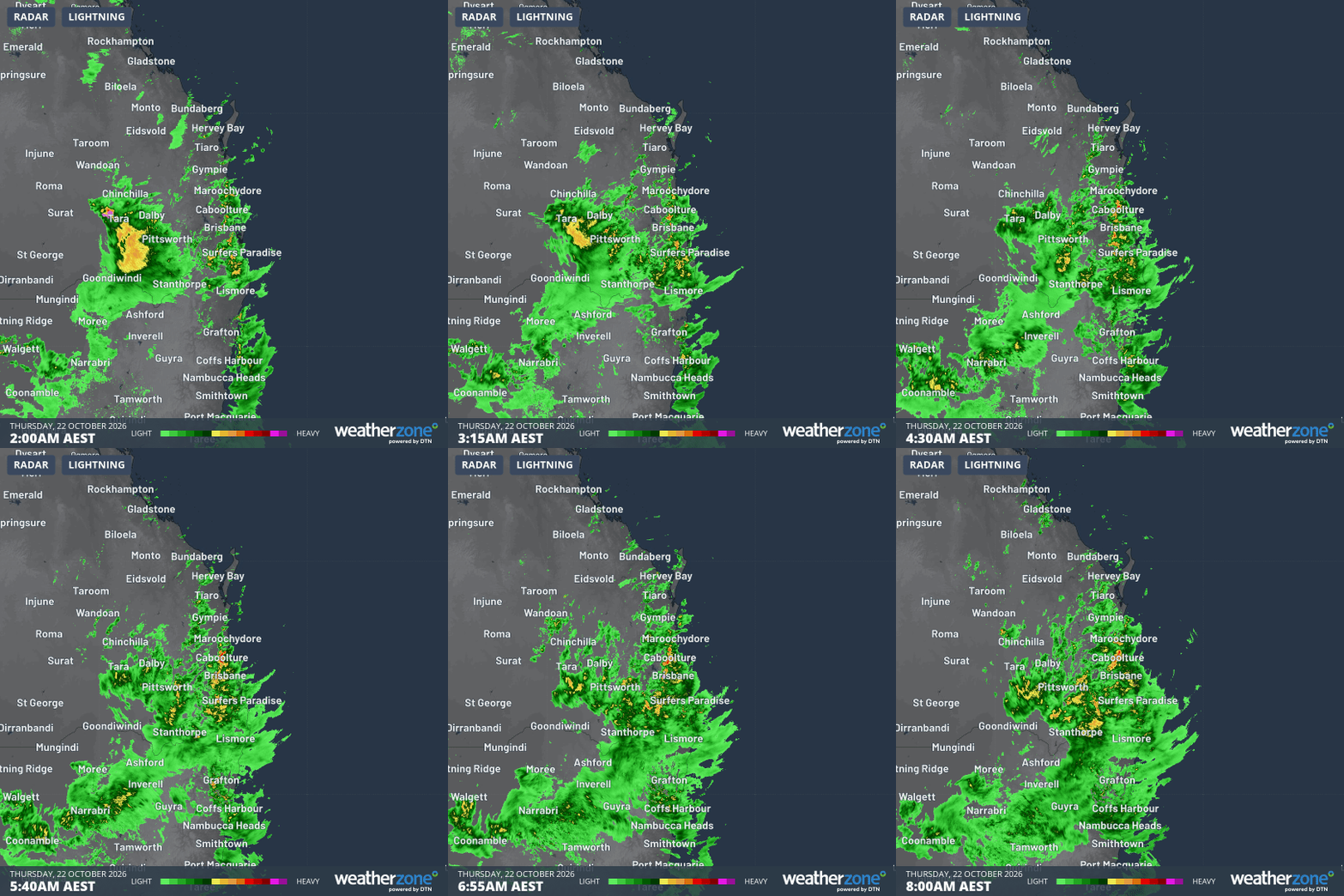
Image: Radar over SE Qld and NE NSW for the six hours to 8 am (AEST) on Thursday, October 22, 2026. Source: Weatherzone.
After steady rain throughout the night, rainfall rates increased dramatically after dawn at many locations in and around Brisbane, especially on the Sunshine Coast.
For example:
- 172 mm was recorded at Caboolture Water Treatment Plant in the 3 hours to 8:30 am.
- 168 mm was recorded at Sheep Station Creek (Morayfield) in the 3 hours to 7:30 am.
- 167 mm was recorded at Round Mt Reservoir in the 3 hours to 8:15 am.
This is the heaviest October rain in decades in several locations, and some records have already been broken.
For example, Beerburrum (at the southern end of Sunshine Coast hinterland) has registered its wettest October day on record with 170.8 mm. The long-term average for the entire month of October is 81.4 mm.
And this has not just been a coastal event. The inland city of Toowoomba received 42.6 mm, its highest October daily total in 29 years and almost as much rain in one day as it received in the four very dry months from June to Setpember this year.
What is causing the intense rainfall?
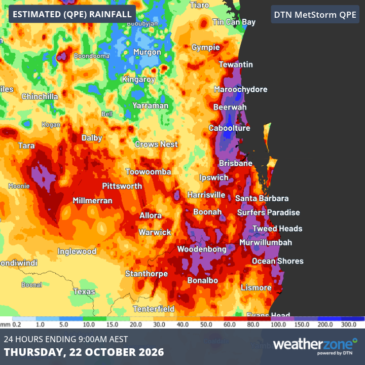
Image: Estimate of Queensland rainfall in the 24 hours to 9 am Thursday (AEST), based on radar data. Source: Weatherzone.
"Abundant atmospheric moisture is interacting with a surface trough and upper-level trough to cause rain across parts of South East Queensland and NE New South Wales," Weatherzone meteorologist Ben Domensino explains.
As Domensino outlined earlier this week, two separate streams of moisture-laden air are colliding over eastern Australia this week.
One stream is being provided by winds in the middle to upper levels of the atmosphere carrying moisture east all the way from the Indian Ocean. A secondary moisture source is coming from winds flowing onshore from the Coral and Tasman Seas in the lower atmosphere closer to the surface.
With abundant atmospheric moisture and a complex system of troughs over Queensland converting that moisture into rain and storms, key ingredients are in place for the current severe rainfall event.
How long will this widespread rainfall last?
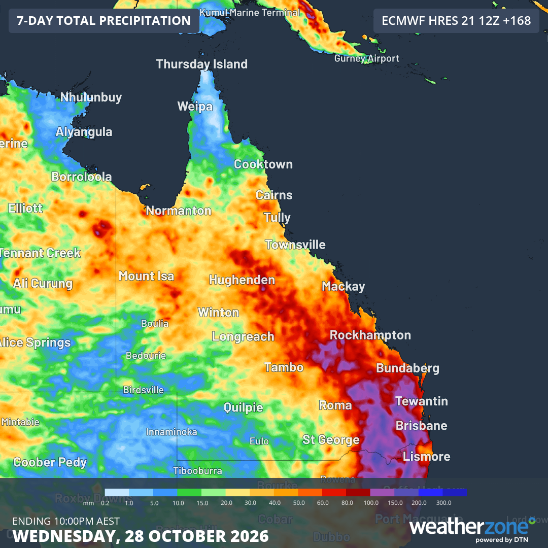
Image: Total accumulated rainfall predicted for Queensland and parts of adjacent states up until next Wednesday, October 28, 2026, according to the ECMWF model. Source: Weatherzone.
Weatherzone meteorologist Jess Miskelly says the general setup with the potential for storm and periods of heavy rainfall will persist until next Tuesday.
"During this time, peak storm days are likely to be Thursday into Friday and also Monday as surface troughs concentrate over the southeast Queensland region," Miskelly says.
"By Thursday, the intensely humid northerly airstream will finally be displaced by a cold front moving in from the west.
"The surface high pressure cell over the Tasman Sea will then shift eastward with dry westerly winds to follow and storm activity shifting to northern Queensland."
Severe thunderstorms possible during Thursday
On Thursday morning, the BoM issued a severe thunderstorm warning for very dangerous thunderstorms that are likely to produce heavy, locally intense rainfall that may lead to dangerous and life-threatening flash flooding over the next several hours.
Locations which may be affected include Brisbane, Caboolture, Ipswich, Nambour, Samford and Woodford.
During thunderstorms, remember to:
- Park your car undercover away from trees.
- Close doors and windows.
- Keep asthma medications close by. Storms and wind can trigger asthma attacks.
- Charge mobile phones and power banks in case the power goes out.
- Put your pets somewhere safe and make sure they can be identified in case they get lost.
- Do not drive now unless you have to because conditions are dangerous.
- Tell friends, family and neighbours in the area.
- Go inside a strong building. Stay inside until the storm has passed.
Please check your local SES in Queensland and NSW for emergency information as this dangerous weather event continues to develop, and remember to check the Weatherzone warnings page for the latest weather warnings and flood alerts.