
East Australian Current pushing unusually warm water down NSW coast towards Tasmania
Sea surface temperatures off Australia’s east coast are running 1–3°C above average as an active East Australian Current drives warm water south along the NSW coast towards Tasmania.
The East Australian Current (EAC) is an ocean current that runs from north to south along Australia’s east coast. It transports warm water from the Coral Sea southwards through the western Tasman Sea. While the EAC usually branches off from the central NSW coast to form large rotating pools of water known as eddies, an extension of the current also continues down towards Tasmania.
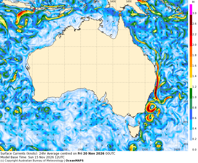
Image: Modelled surface currents on Friday, November 20, 2026, showing the EAC flowing along Australia’s east coast and forming large eddies over the Tasman Sea. Source: Bureau of Meteorology.
The EAC will flow strongly near the NSW coast this week, with computer models predicting that it will be moving south at more than 3 knots (around 6 km/h) near the state’s north coast. The current will also break off into large eddies off the south coast of NSW and near Bass Strait, before continuing towards eastern Tasmania.
The influence of the EAC is evident in the current state of sea surface temperatures along Australia’s east coast. Abnormally warm water is flowing south near NSW and towards Tasmania. With no strong low pressure systems to mix cooler deep water towards the surface in recent weeks, sea surface temperatures are now pushing 3°C warmer than normal in some areas.
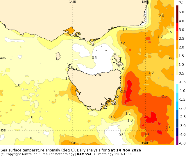
Image: Sea surface temperature anomalies near Tasmania on Saturday, November 14, 2026, showing water temperatures 3°C above average to the east of the state. Source: Bureau of Meteorology.
This warmer-than-normal water will enhance evaporation and increase the amount of moisture in the atmosphere, providing additional atmospheric moisture that can enhance rainfall when suitable weather systems move through eastern and southeastern Australia.
The EAC also helps move fish and other marine animals down Australia’s east coast and can help flush waterways and coastal areas in eastern Australia.
One of the lesser-known impacts of the EAC is sea level, which can change by more than half a metre when eddies form. This week, the sea level off the south coast of NSW is predicted to be more than 60 cm higher than usual due to an eddy centred southeast of Ulladulla.
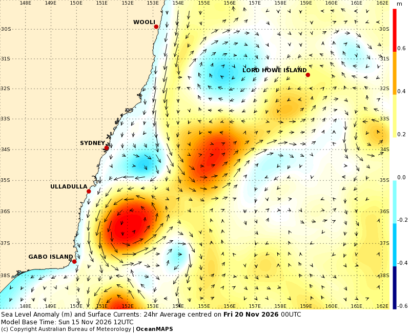
Image: Modelled sea level anomaly and currents near NSW on Friday, November 20, 2026. Source: Bureau of Meteorology.
The EAC flows throughout the year but fluctuates in strength and shape. It typically moves faster in summer and gets weaker in winter. The EAC is also an active area of climate research because studies show that climate change could be making the EAC stronger and shifting it further south.