News
Home>Weather News>Arctic blast to bring subzero temperatures to Northeast U.S. this weekend
Arctic blast to bring subzero temperatures to Northeast U.S. this weekend
Another burst of arctic air is set to sweep across the Northeast United States this weekend, with temperatures forecast to drop nearly 20 degrees Fahrenheit below average in some areas.
The month of January was a cold month for much of the eastern half of the United States with rounds of brutally cold air moving through. Temperatures averaged 3 to 4 F below average for the Northeast, Great Lakes, and Ohio Valley.
However, the Northeast won’t escape these cold temperatures just yet, with another round of arctic air to settle in this weekend.
Cold Temperatures Enhanced by Recent Snowfall
On Jan. 24 to 26, much of the Northeast received heavy snow that resulted in some areas of Massachusetts and Connecticut seeing over 15 to 20 inches. Both Bridgeport and Hartford, Connecticut, recorded snowfall around 15 to 16 inches on Jan. 25, leading to the second snowiest January on record. Much of the snowfall from that late January storm still blankets large areas of the Northeast.
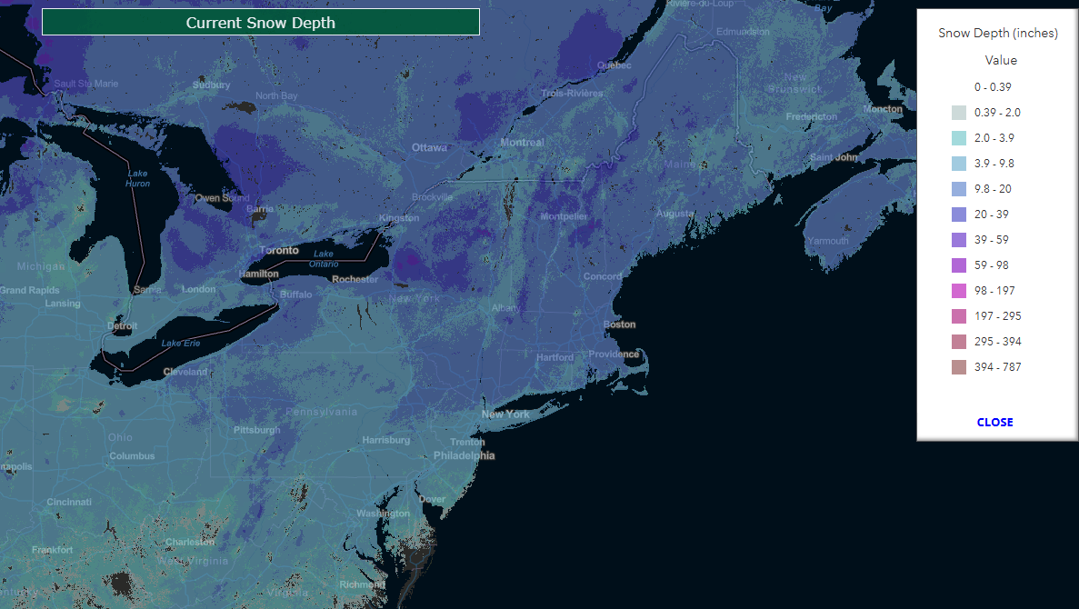
Image: Current snow depth across much of the Northeast U.S. exceeds 10 inches. Source: United States Department of Agriculture.
Before this weekend’s cold air arrives, more snow is forecast as a storm system from Ontario will move into the Great Lakes and Ohio Valley on Friday before shifting east into the Northeast on Saturday.
Most areas will see around 1 to 4 inches of snow from this system. The heaviest snow is expected across the Appalachian Mountains in West Virginia where the higher elevations in the east could see over 8 to 10 inches of snow.
As the cooler air arrives Saturday and Sunday, the fresh snowfall and deep snowpack from late January will likely lead to even colder temperatures versus if the snowpack was relatively light or non-existent.
Widespread Sub-Zero Temperatures
As a cold front moves through the Northeast on Saturday, some places may see their high temperatures occur during the morning hours before temperatures plummet throughout the day. Buffalo, New York, will see a high of 15 F around midnight EST Saturday with temperatures dropping close to zero F by 10 a.m. EST.
By Saturday night into Sunday morning, low temperatures will approach minus 20 F across the Adirondack Mountains of New York. Inland areas of Massachusetts and Connecticut will see sub-zero temperatures with lows in the single digits above zero F right along the coast.
High temperatures on Sunday afternoon will be hovering right around zero F for northern Vermont and northeast New York while warming up into the teens across southeast Massachusetts and Rhode Island.
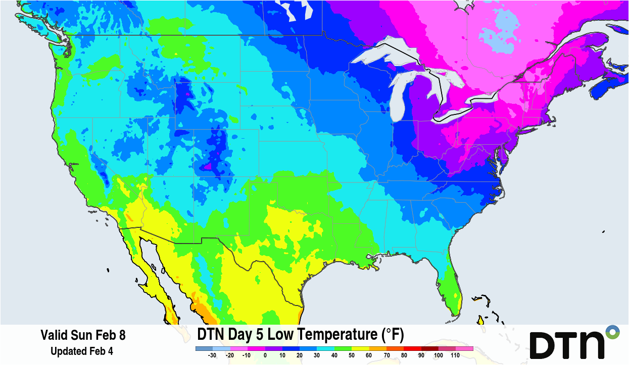
Image: Widespread sub-zero temperatures are expected across the Northeast U.S. Sunday morning. Source: DTN.
Winds will also factor into how cold it will feel outside on Saturday and Sunday. Behind the cold front, winds will be from the northwest reaching sustained speeds around 10 to 20 mph for most areas of the Northeast. A few higher elevations could see sustained winds top out around 25 mph.
Wind gusts will be around 30 to 40 mph for southern New York into Massachusetts and Connecticut. When factoring in the wind, the wind chill or feel like temperature will hit minus 35 F in the Adirondacks Sunday morning while Boston and New York City could see wind chills around minus 20 F.
Temperatures Slowly Moderate Next Week
Luckily, the brutally cold temperatures won’t last very long into next week. Temperatures will remain below average for much of the Northeast on Monday with lows approaching minus 10 to minus 20 F in Vermont and New Hampshire Monday morning.
By Wednesday, temperatures will be within 5 F of average. High temperatures during the middle of next week could get into the lower or mid 30s for southeast New England, which could also start to put a dent in the deep snowpack.