Nachrichten
Startseite>Wetterbericht>Lake-effect snow to impact Great Lakes this weekend
Lake-effect snow to impact Great Lakes this weekend
A blast of cooler air and a storm system will move into the Great Lakes and Ohio Valley this weekend, causing widespread snowfall including areas of potentially heavy lake-effect snow downwind of the Great Lakes. This lake-effect snow could lead to measurable snowfall across much of Michigan, northern Indiana, and Ohio from this weekend into early next week.
How does lake-effect snow form?
Lake-effect snow becomes more frequent in the late fall and winter months due to cool air moving across relatively warmer water in the Great Lakes.
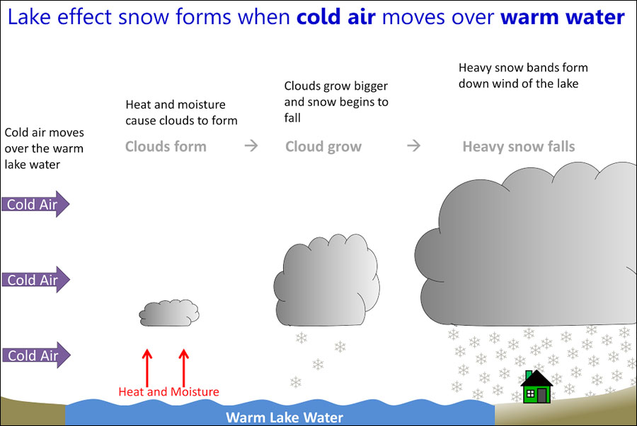
For lake-effect snow to develop, cold air from Canada drifts south across the open waters of the Great Lakes. As water temperatures in the Great Lakes are often warmer than the air temperature, warmth and moisture get transported to the lower parts of the atmosphere. This warm, moist air will eventually rise and condense into clouds that can produce snow.

Image: Cold air moves over warm lake water to form clouds that produce lake-effect snow showers. Source: NWS.
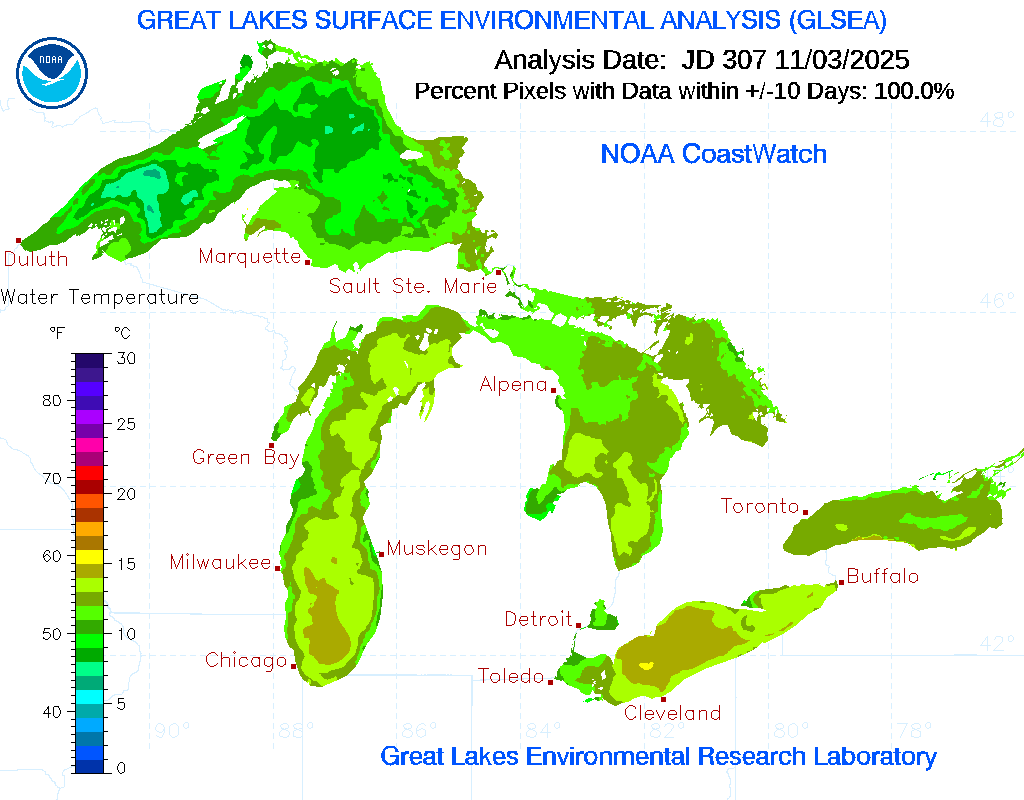
As of November 3, water temperatures across the Great Lakes spanned between 45 and 60 degrees Fahrenheit. Some of the warmest waters are located across southern Lake Michigan and Lake Erie. Lake Superior is the coolest with water temperatures generally below 55 F.

Image: Water temperatures across the Great Lakes on November 3, 2025. Source: NOAA.
This weekend, cooler air from Canada is expected to drift over the lakes. Saturday morning’s low temperatures could approach the 20s in Michigan’s Upper Peninsula. Mid 30s are possible across central Michigan. By Sunday morning, low temperatures could approach the low to mid 30s for northern Illinois with widespread low to mid 20s for portions of Wisconsin, northern Iowa, and Minnesota. One of the main ingredients for lake-effect snow will be present this weekend with the cooler air sweeping across the warmer lake water.
Potential impacts across the Great Lakes this Weekend
Computer models are hinting at a widespread lake-effect snow event developing across the Great Lakes from this weekend, with heavy lake-effect snow bands possibly developing in western Michigan, northern Indiana, and northeast Ohio.
A low pressure system is expected to move across the Great Lakes and northern Ohio Valley Saturday night through Sunday morning. Cooler air on the northern side of the low could lead to spotty snow showers in southern Minnesota, southern Wisconsin, and northern Iowa before becoming more widespread across lower Michigan. Scattered rain showers are expected farther south.
After the low pressure system passes to the east, cooler air from Canada and gusty northwest winds will begin producing lake-effect snow showers across the Great Lakes later Sunday into Monday. The northwest winds will aid in producing bands of lake-effect snow as it blows cooler air across the bodies of water and this allows the warm, moist lake air to condense into clouds and eventually produce snow.
From November 8 to 10, a swath of 4 to 8 inches of snow could fall across the lower half of Michigan. On the east and south sides of Lake Michigan as well as the south side of Lake Erie, some of the lake-effect snow showers could lead to isolated snowfall totals exceeding 6-10 inches in some spots. However, the exact spots where heavier snow will fall remains uncertain as models continue to resolve the exact track of this weekend’s low pressure system. Slight shifts in the center of the low could cause heavier snow to shift north or south.